But it is well-signposted and should cause few problems.
At normal summer levels, the River Avon is about 7 to 8 foot above the Old Avon and River Severn.
Passage between the Severn and Avon is facilitated by the Tewkesbury lock.
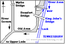
The Rivers Severn and Avon at Tewkesbury
|
| The natural confluence of the River Severn and the River Avon has been modified by Man and can be confusing to canal boats navigating it for the first time. But it is well-signposted and should cause few problems. At normal summer levels, the River Avon is about 7 to 8 foot above the Old Avon and River Severn. Passage between the Severn and Avon is facilitated by the Tewkesbury lock. |
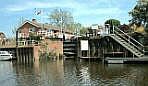
| The Avon or Tewkesbury Lock. The entry lock viewed from the Old Avon, the weir stream (see map above) which enters the River Severn. Craft lock up here to the River Avon, or down to the Severn level; a difference in level of about 7 to 8 foot. |
 |
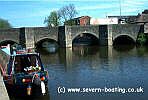
| King Johns Bridge. Immediately to the north of Avon Lock, this is the critical entry bridge for the River Avon. At normal summer river level, the height of the centre of the largest span is 10 foot. If you can pass under this bridge you will be able to pass under all the other bridges on the Avon as far as Stratford upon Avon. |
 |
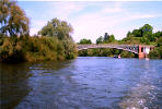
| The Mythe Bridge This graceful bridge was designed by Thomas Telford and opened in 1826. It is constructed of iron and has a 170 foot span across the River Severn. It is located a short distance north of the entry channel to the River Avon. |
 |
Photographs courtesy of Severn-boating